Traditional place names maps are on their way to Arviat homes, thanks to the work of local Elders and the Nunavut Heritage Trust.
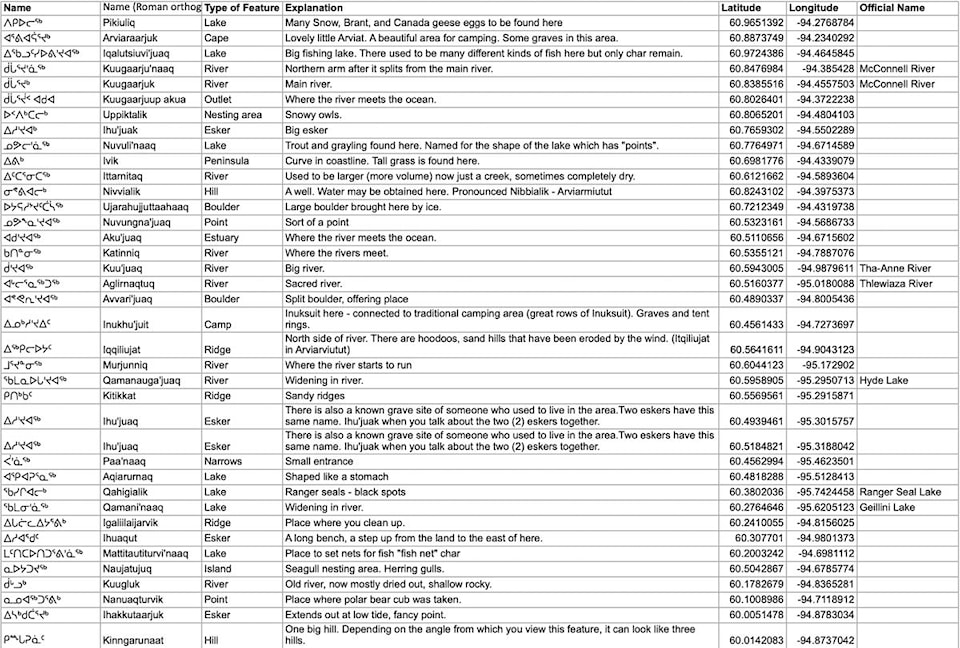
The maps are part of a long-running project by the organization to collect traditional place names and create maps for each community or region in Nunavut. The trust has documented more than 10,000 traditional names since beginning this effort 20 years ago.
READ MORE: Traditional place names project bringing knowledge back to Nunavummiut
Many Elders contributed to the Arviat map during the trust’s community engagement sessions, but one sticks out: Donald Uluadluaq.
“We were told we better hurry up and get there because he wasn’t going to be alive much longer,” recalled Lynn Peplinski, traditional place names manager for Nunavut Heritage Trust, while she and her team were compiling information for the Arviat map.
She quickly made plans and got on a plane to meet him in the nursing home in Arviat with his daughter. Uluadluaq was connected to an oxygen tank and needed frequent naps, but over the course of seven days, Peplinski and her team went through every name on the map with him.
“He passed away 10 days after we left,” she said, noting how close the timing was.
The Arviat maps have something previous ones don’t, too: they’re waterproof. Two copies of the map will be sent to every household in Arviat.
Peplinski said there are remarkably few conflicts that arise in place names during her community tours. Most Elders have clear ideas of what’s what, and if they don’t, they suggest the right person to talk to.
“The Elders that we work with are so careful to make sure that what is written down is exact,” said Peplinski. “What usually happens is they’ll identify names for a certain area, and then they’ll get to a boundary and they’ll say, ‘Beyond this point here, you really should talk to so and so.’ So even if the person might know the names beyond the boundary, they don’t feel like they’re an authority.”
What separates Indigenous naming conventions and European ones, explained Peplinski, is that Indigenous names tend to describe the area – “big mountain” or “good place to hunt seals” – whereas European names tend to refer to travel sponsors, kings or other people.
“It’s a very interesting difference between the European way and the Indigenous way of naming places,” said Peplinski, adding that the Indigenous way makes “the land come alive.”
It is rare to find Indigenous places named after people, but there are a few, such as Mittimatalik, or Pond Inlet, which is named for where the remains of Mittima are. Otherwise, Inuit would not traditionally name places after people because they didn’t want to give the sense that any single person owned that land.
In Arviat, and commonly in Nunavut, the sad truth is some of the traditional names will never be captured, as they were lost when Elders familiar with those areas passed on.
What’s important for Peplinski now is that this project doesn’t end with waterproof maps, as nice as those may be – she wants the Indigenous place names to be the official names with the Government of Canada.
“It’s really important that these projects follow through to the end, the end being that the names become official,” she said. “As long as the names are not official, they’re vulnerable to being lost.”