Two teams of scientists with Natural Resources Canada will make their annual 3,500 kilometre trip across the High Arctic this month to monitor weather stations and observe glacial changes which, since 2002, have been dramatic as 1,000 giga tonnes of ice has melted.
“To put that into perspective, 1,000 (giga tonnes) of ice would cover New Brunswick, Nova Scotia, and P.E.I. in a layer of ice over 7.5 metres thick,” said Dr. Bradley Danielson, a researcher with the Geological Survey of Canada (GSC).
The trip across the High Arctic has been occurring well before 2002, however, as professionals from GSC have been making the trek ever since 1959. New measurement practices were established at some of the Arctic glaciers in 2002, Danielson said.
Two other researchers will accompany Danielson to analyze five of the ice caps. This includes the Agassiz, Meighen, Devon, and Grise Fiord ice caps in Nunavut, as well as the Melville ice cap in the Northwest Territories.
A second team, led by GSC scientist Mark Ednie, will observe the NWT’s Nahanni National Park Reserve to monitor the Bologna Glacier, plus two other locations in Alberta and British Columbia.
Making their way out to the glaciers, the team members expect to see a continuation of a trend of thinning ice, said Danielson.

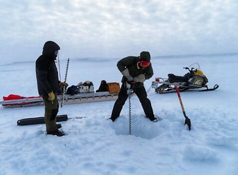
This is determined through measurements taken with five-metre-long aluminum poles used at each of the target glaciers.
“There’s an established set of measurement poles on these glaciers,” said Danielson. “We drill a hole in the ice, we put the pole in, and that’s our reference marker. We can use that to measure the distance from the top of the pole to the ice surface, then we know where last year’s ice surface was, (so) when we come back this year, we can measure how much snow accumulated in that area. We can also measure how much ice melted the summer before. So we’re looking for that balance.”
With regards to monitoring weather stations in the area, the team assesses data received from the year-round facilities to better understand the seasonal fluctuations of temperatures in different regions.
However, Danielson noted, issues can occur that affect the station’s readings.
“Occasionally, they get knocked over or they fall over,” he said. “For instance, (in) 2020, we were really worried that a lot of our weather stations would be damaged, just because we didn’t anticipate leaving them for more than a year without maintenance.
“We got lucky in a few cases that some of them are still standing,” he added. “Some of them were buried or knocked over. Then yeah, we do we lose pieces of that temperature record or climate record.”
Overall, each ice cap has at least one weather station, but there may be as many as five, depending on the glacier.
“I think there’s three on the Agassiz ice cap, and five on the Devon ice cap, just because those are much bigger sites,” said Danielson.
All the data gathered from the team’s journey goes towards analysis for predictions regarding things such as rising sea levels.
“So what we’re doing is really collecting the ground truth data that allows us to make bigger picture assessments of glacier changes,” Danielson said. “Then that type of information is used to help predict how much glacier melt is occurring in Canada, and then how much glacier melt may contribute to future sea level rise for instance.”